![]()
I would like a Full Page View. Before Ordering an item please see Terms of Sale.
NOTE:  This symbol points to an item for which there are on-line photographs available in one or more places in that item's description. Click' on an underlined item to bring up an image. If you would like to see an item for which we have not provided a photograph send us an email and we will email a photo of the item to you.
Sizes (height x width to the nearest half centimeter) are platemarks or, lacking a clear mark, the image, exclusive of border texts. Most items matted (though not with archival quality board.)
Descriptions used in our catalogues.
![]() Buy with confidence! Your credit card transaction is secured with SSL encryption.
Buy with confidence! Your credit card transaction is secured with SSL encryption.
For your convenience you may use this Currency Converter to establish exchange rates.
| GO TO AFRICA & HOLY LAND | GO TO THE AMERICAS |
| GO TO ASIA | GO TO EUROPE |
BY AN ENGLISHMAN & THE FIRST TO USE MERCATOR
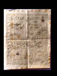
Foxed, otherwise good condition. This copy has the following three additions inked in a contemporary hand in the appropriate regions: the province of Mayne, Mafors Patent, and Matachufsetts Colonie. This rare chart is noted for having place names in several languages, many being American Indian. Map titles include 'America Norambega Nova Anglia' and 'Nova Belgia' (which depicts the area of Dutch territorial claims.) There is a compass rose in the upper right corner, the title cartouche in the upper left quadrant and a ship off the New Jersey shore. The engraver's signature is in the lower right corner. Covers the eastern seaboard from present-day Canada south through New Jersey.
Fine condition on this rarity with a little foxing confined almost exclusively to the margins. 2 mm. tear in the top margin. Superior condition to the Phillips copy.
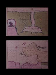
Shows southern Florida, Bahamas, Cuba, Jamaica, part of Hispanola, the Yucatan peninsula and many of the small islands. Ornate title cartouche in upper right quadrant. Latitude and longitude grid lines, including Tropic of Cancer. Compass rose in upper right corner, engraver's signature in lower left. Near the lower middle of the map, a sailing ship.
The first edition of both above maps which are quite rare. Baron Nordenskiöld stated "In how many of the large libraries of Europe one seeks in vain for ... the Arcano dell Mare." --Philip Lee Phillips. A list of the geographical atlases in the Library of Congress. Washington, D.C.: G.P.O.; 1909, page 206, entry 457.
"Even by the standards of his time, Sir Robert Dudley was a remarkable character, whether as adventurer, scientist, mathematician, naval architect or navigator. He was the illegitimate son of one of Queen Elizabeth's favourites, the Earl of Leicester, who was eventually induced to acknowledge Dudley as heir. Dudley claimed the titles of Duke of Northumberland and Earl of Warwick and was known by them throughout his years in Italy.
At the age of twenty-one he voyaged to the West Indies with an expedition in the Earwig and the Bear, which combined harassment of Spanish shipping with exploration of the coast of Guiana. On return to England he took a prominent part in the Earl of Essex's raid on Cadiz in 1596 and received a knighthood for his services but, soon afterwards, matrimonial problems led to loss of favour at Court and to self-imposed exile. He spent the next few years travelling in Italy and finally, in 160?, settled in Florence where his skills soon brought him fame and the patronage of the Grand Dukes of Tuscany. In their service he spent the following thirty years compiling his monumental sea atlas Dell' Arcano del Mare (Secrets of the Sea), a 6-volume work including 2 volumes of maps and charts and 4 volumes covering the whole field of navigation, astronomical tables, shipbuilding and kindred subjects. Although produced in Italy it was the first sea atlas by an Englishman and the first in which all the charts were drawn on Mercator's projection. Material for so splendid a work must have been drawn from many sources; in addition to his own experience, it is known that he had at his disposal the logs kept by his brother-in-law, Thomas Cavendish, the circumnavigator, and other information on the latest discoveries provided by John Davis and Abraham Kendal, famous explorers of the time."
--- From Chapter 15 of Antique Maps - A Collector's Handbook, by Carl Moreland and David Bannister.
These charts were engraved by Antonio Francisco Lucini who stated in the dedicatory epistle to the second edition (1661) that to complete the atlas he worked in seclusion in an obscure Tuscan village for twelve years and used no less than 5,000 lb. of copper in the process.
1646 -- 1647 Dell' Arcano del Mare. Florence: published by Francesco Onofri
1661 Re-issued in Florence by Guiseppe Cocchini as Arcano del Mare. This second edition (Phillips 3428) is differentiated from the first by the addition of the cypher L060 to the cartouche or upper corner of all but 24 of the charts and prints. [The cipher is always L superscript 0 followed by a numeral (whose number varies) superscript 0.] The 24 unmarked sheets may, perhaps, be identified by the paper stock.
 |
Sheet size Engraving on paper $595.00 Inquiry | Baye et ville de Havana ou S. Christoval (21.5 x 31.5 cm.) Bay et Chateau de Porto Bello (21.5 x 31.5 cm.) Leyden: Mortier; ca. 1700 Fine condition. Original color. Three maps on one folio sheet. |
 |
31 x 38 cm. medium $75.00 Inquiry | Jizni America [South America]. Prague: ca. 1880 Fine with a little dust-soiling on the right one-sixth of the sheet. From Zemp. Atlas , plate XIII. Color outline. |
|
|
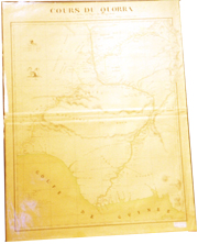
29 x 63 cm. medium SOLD | Detailed map of the Rev. Dr. Livingstone's route across Africa constructed from his astronomical observations, bearings, estimated distances, sketches, &c. &c. [London] Litho: 1857 Folded but in very good condition. 'Mappa 1' in upper right corner. Red line marking the route. |
|
|
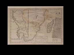
38 x 58 cm. medium SOLD | South eastern Africa. Map of the river Shire, the lakes Nyassa & Shirwa, the lower courses of the rivers Zambesi & Rovuma, based on the astronomical observations & sketches of Dr. Livingston. Constructed by ---, New York: Harper & Brothers; 1865 Showing wear from repeated folding. Taped tear in upper left in a blank area, partially trimmed to the plate on left margin. Three place names underlined. This and the foregoing map are probably from a book. Red line marking the route. |
 |
28 x 34 cm. medium $175.00 Inquiry | Charte worauf das land Canaan und Gilead nach den XII stämmen Israels vorgefstellet wird. Von --- zur gesehichte Iosua, seite I. 1785 Fine condition. Perhaps a German edition of the Dutch atlas adapted/published by Bachiene with over half the plates attributed to Emanuel Bowen. |
|
|
22.5 x 33.5 cm. medium $125.00 Inquiry | Carte de la haute et de la Basse Guinée, depuis la Riviere de Sierra Leona, jusqu'an Cap Negro. Paris: 1780 Light foxing at centerfold, otherwise fine. Outline color. |
 |
22.5 33.5 cm. medium $125.00 Inquiry | Carte du canal de Mosambique, contenant L'Isle de Madagascar avec les côtes D'Afrique, depuis le Cap de Bonne Esperance, jusqu'á Melinde. Paris: Engraved by André; 1762. Water stain at top middle of sheet. Outline color. Bonne, a French engraver and hydrographer, probably published this map of the Mozambique Channel, Madagascar and the southern coast in his Atlas Maritime of 1762. There is a detailed inset of the Cape of Good Hope from St. Helena Bay to False Bay, being a fairly good indication of the bays and the place names in the interior. -- Norwich 173. |
 |
size Watercolor on paper $.00 Inquiry | TITLE Place: circa Fine condition. Hand drawn in light yellow watercolor. |
|
|
22.5 x 26.5 cm. medium $60.00 Inquiry | Africa. Gestochen von ---. Np, nd. Ca. 1830 Good condition, right margin trimmed to just inside platemark and couple of small, unobtrusive worm holes. Outline color. Plain rectangular title cartouche in lower left corner and legend box, in German, in lower right. 'IV' at top right of map with the words 'Länge des Meridans von Paris' at center bottom and 'Länge von der Infel Ferro' at the top center. |
|
|
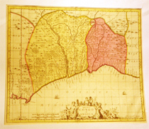
51 x 58.5 cm. medium $550.00 Inquiry | Guinea propria, nec non Nigritiae vel Terrae Nigrorum maxima pars ... Anvillianis .... Prof. Has: 1743 Fine condition with a couple minor spots of dust soiling. Original color. Vignette in lower left of Benin with natives working ivory tusks and going about daily village activities (see photo at beginning of this catalogue.) Covers Senegal to Fernando Po. Taken from D'Anville by Johann Baptist Homann (1663-1724) and his heirs who dominated German mapmaking for a hundred years. |
|
|
size medium $95.00 Inquiry | North Africa and the Mediterranean World. London: 1812 Fine condition. Original wash color. Description. |
|
|
31 x 36 cm. Woodcut $750.00 Inquiry |
Affrica Tabula Nova Basle: ca. 1580 Fine condition with four small matching holes in lower right & left quadrants. Some paper creasing at the center fold. Across the top: "Africa/ Lybia/ Dozenlandt/ mit allen knigreichen/ so jetziger zeit darumb gefunden werden." Text on verso. Norwich 14, Tooley, Collector's Guide to Maps of Africa. According to Norwich, Münster's Cosmographia was issued from 1580 onward with the maps based on Ortelius (see Map Collector's Series No. 29). "This map could be regarded as coming from the second edition of Münster: the addition of a portion of the coast of Portugal [ought to read Brazil] makes it recognizable as such. The technique of the drawing is different from the Münster woodcuts of Africa. The coastline is jagged, with prominent bays, there are many lakes and rivers and the geography is somewhat fictitious except for certain well-known places and rivers. There are two small sailing vessels and one sea monster. The lower left cartouche is a simple rectangular, slightly ornamented box containing the title in a florid calligraphy which is also used for the place names." |
|
|
size Woodcut $250.00 Inquiry |
Egypt & Arabia Circa 1560 Very good condition. Framed and glazed. Scenes on the map include the snaking route Moses and tribe wandered for 40 years (complete with numbers that once must have had a matching key), the parting of the Red Sea, the golden calf with dancing figures, etc. |
 |
VALK, ca. 1703-09 41 x 49 cm medium $.00 Inquiry |
Congo et Angola. Amsterdam: ca. 1703-09 Fine condition. Very good condition with four centimeters of iron gall ink burn-thru on one of the colored borders. Original color. There is a decorative cartouche at bottom center with putti, dolphins, etc. |
 |
31.5 x 67 cm. medium $195.00 Inquiry |
Guinea zwischen Sierra-Leona und dem aequator. Verfasst von Herrn D'Anville verbefsert herausgegeben von Heern--- 1786 Fine condition with two small flecks of foxing to plate. Very large margins. Outline color. Gold coast inset at lower center. |
|
|
31.5 x 67 cm. medium $175.00 Inquiry |
Guinea zwischen Sierra-Leona und dem aequator. Verfasst von Herrn D'Anville verbefsert herausgegeben von Heern--- 1786 Fine condition with four small flecks of foxing to the plate. Two cm. tear at top margin. Light finger smudging in upper right margin and small water stain in lower left. Gold coast insert at lower center. |
|
|
SCHENK, ca. 1703-09 43 x 57 cm. medium $425.00 Inquiry |
Nigritarum Regnum Amsterdam: ca. 1720 Fine condition with some off-setting of the brown coloring used to fill the area of present-day Cameroun. Original color. Lower right vignette w/ African holding tusks, pearls, a parrot, etc. Lower left dedication cartouche by J. Jansson. Valk & Schenk, in partnership, acquired some of Blaeu's and Jansson's copperplates. |
|
|
Image size 55.5 x 90.5 cm. medium $175.00 Inquiry |
Carte du Sénégal, de la Falémé et de la Gambie jusqu'aux limites ou ses rivières ont été explorées, ... Dressée sous la direction du Colonel du Génie L. Faidherbe, gouverneur du Sénégal ... par le Bon. Brossard de Corbigny, capitaine de frégate, .... Publiée par ordre de L'Empereur sous le ministère de S.E.M. le Comte P. de Chasseloup-Laubat, .... Engraved by Jacobs: 1861 Fine condition. Description. |
|
|
33 x 39 cm. medium SOLD |
Afrika Ca. 1880 Very good condition with some dust-soiling and foxing to the left one-sixth of the sheet. Color outlines coded to European control. From Zemp. Atlas, plate X with an inset of Egypt on the middle left and an inset of Algeria and parts of Morocco & Tunisia at bottom right. |
|
|
49.5 x 63 cm. medium $295.00 Inquiry | Gouvernement general de Bretagne. Paris: 1751. Fine condition with nice title cartouche. Outline color. |
|
|
49.5 x 57.5 cm. medium SOLD |
Magna Britannia complectens Angliae, Scotiae et Hyberniae regn. in .... Across the top: "A general map of Great Britain and Ireland with part of Holland, Flanders, France & agreable to modern history. By the heirs of late Mr. Homann at Nurenberg." London: 1720 Very good condition with some light, tan foxing. A few letters lost at top center fold. Some color outline. Inset of Shetlands and Orkneys in upper right corner. Elaborate title cartouche in upper left corner. |
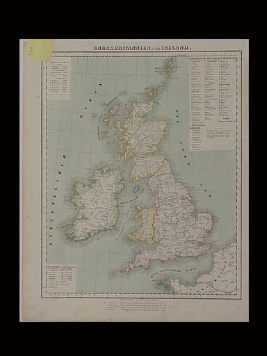 |
37 x 30 cm. Lithograph by Thomas. $50.00 Inquiry | Grossbritannien und Ireland. Glogau: ca. 1890. Very good with minimal foxing in margins and light water stain in upper right quadrant. Color outline. |
|
|
26 x 19.5 cm. medium $75.00 Inquiry |
Die Orkney's oder die Orkadischen Inselm. Prag: 1810 Dark smudge in upper right margin not near image, otherwise fine. Description. |
 |
size medium $ Inquiry |
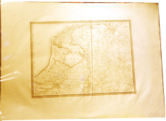
Zuider Zee Place: Publisher; Date Fine condition. Original color. Description. |
We are cataloging these items:
CHINA
MACAO
FORMOSA

© 2000-2002 Coup de Foudre, LLC